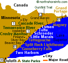
|
Lake Superior Fun Facts Largest freshwater lake in the world, one inch of surface water is equal to 553 billion gallons.
Superior is the coldest, deepest, and highest in elevation of any of the Great Lakes. Old timers say that Superior doesn't give up her dead. If you go down on Superior, chances are your body will not be found. This is one lake
that you need to know what your doing if you play in her waters. Last time Superior totally froze over was 1997.
In 2003 the lake almost froze over
again, except the western areas along the Minnesota shoreline.
Superior is being effected by a drought, lack of normal snow and
rainfall accumulations the past four years. This has caused Lake Superior to reach low waters level not seen in recent decades.
Lake Superior was conceived 1.1 to
1.2 billion years ago during the mid-continent rift. For over 2
million years Superior was repeatedly inundated with thick flow of
lava. During the periods between these flows, the crust
down-warped, creating a basin that accumulated sediments until the
cycle begun again with the next flood of molten lava.
Weather and climate
is moderated by Lake Superior, winter is warmer and summers are
cooler. This effect is strongest when the winds blow off her
waters and is most pronounced along the immediate shorelines and
on the slopes that face the lake. Between late spring and late
fall the shore can be shrouded in fog when the land surrounding
Lake Superior heats up much warmer than the water. This warm
season fog occurs when when moisture in the warm air condenses as
it flows over the cold lake. Duluth, Minnesota has an average of
52 days of heavy fog each year. Most of Lake Superior shipwrecks
occurred during fall storms called "northeasters." These storms
build when low pressure systems pass over the lake.
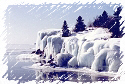
Winter temperatures
rarely dip below -30�F/-35�C, inland temps however can go well
below -30�F/-35�C. During most winters the lake can become 40-95%
covered with ice. Occasionally the lake freezes over completely. Length: east-west 350 miles/563
km
Width: south-north 160 miles/257
km Elevation: approx. 602 feet/183
meters above sea level
Basin population: 425,500+
U.S. citizens and 181,500+ Canadians
Shoreline Total: 2,980 miles/2938 kilometers including island shorelines Water Surface Area: 31, 7000 square miles/82,100
square kilometers Average
Depth: 489 feet
Number of fish species: 78 Maximum Depth: 222 falthoms or 1,333 feet,
406 meters, 46 miles southwest of caribou Island or 5 degrees and 25 miles from Grand Island Picture Rocks National
Lakeshore. In the area west of Marquette, Michigan. High Water Level: 602.86 feet above sea level in 1876 Low
Water Level: 598.23 feet above sea level in 1926 Water Clarity: 65-75 feet of visibility
in some areas, average is 24 feet/8 meters Water Volume:
3,000,000,000,000,000 gallons of 440 trillion cubic feet or 10% of the world's fresh water.
Enough to flood North and South America to one foot deep. Flushing Rate: 400-500 years for a complete water change Detention Rate: 191 years for a drop of water to remain in the lake Flow Rate Into Lake Huron: 73,7000 cubic feet/2,124
cubic meters per
second Average Water Temperature: 40�
F/4�
C Calmest months: June and July
Stormy Months: October and November Maximum Wave Height Recorded: 31 feet
Yearly average number of vessels
that visit the Duluth/Superior port: 1000
Yearly average visitor count:
3-4 million persons
Shipwrecks Recorded: 350 and more than 1,000 lives have been lost. [more shipwreck info]
Duluth Harbor Picture | Grand Marais, Minnesota Harbor Pictures |