|
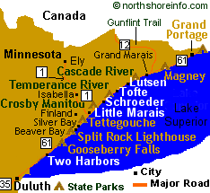
Map is clickable
|

On Hwy 61 40 miles NE of Duluth/12 miles NE of Two Harbors
218-834-3855 (visitor center)

Sawtooth Outfitters offers canoe, kayak, bike,
cross country and downhill ski rentals.
|
Gooseberry State Park in Minnesota invites the public to re-visit the recently completed trails, overlook plaza and highway/pedestrian bridge.
Visitor Center
Open year round; offers naturalist and interpretive programs, exhibits, restrooms & a gift shop.
Heated restroom facilities at Gooseberry are usually available through most of October, but generally not during the winter months.
Waterfalls
five waterfalls north of Highway 61 down to Lake Superior
Historic Sites
several buildings & the original bridge are part of the Civilian Conservation Corp and are on the National Register of Historic Places
Picnic Area
tables & an enclosed area
Hiking
18 miles; part of the Superior Hiking Trail & several small spur trails to waterfalls, overlooks, up the river and down to Lake Superior
Mountain Biking
12 miles; hard-packed dirt trails begin north of the highway
Fishing
in the river and on Lake Superior for steelhead, brook trout and salmon.
Camping
70 drive-in sites; including 3 pull-through sites (40' RV length limit),1 kayak site, flush toilets and showers, a dumping station, a group site, and public phones; firewood and ice are sold at the park
Cross-country Skiing
20K; all groomed for classic (diagonal) stride with a warming house
Snowmobiling
3 miles within park & 6-mile access trail to the North Shore State Snowmobile Trail
Birding
bird checklist for Gooseberry Falls State Park
Two Harbors Lodging and Dining
Beaver Bay Lodging and Dining
Maps of Gooseberry Falls State Park
Make a reservation at Gooseberry Falls State Park
North Shore Fall Color Tours™
Fall colors are spectacular on the North Shore...check out our current color and bird migration reports, we offer daily reports and more than 25 different routes for viewing fall colors!
All North Shore State Park Maps
Minnesota's North Shore State Parks
|